This first picture is the corner of Kalamath and
This next picture is at 2nd and Kalamath. A mammoth tooth was found here. Fossils of extinct mammals are often found in alluviums in the Denver area.
This picture is perhaps what the alluvium looks like, a mix of gravel and sand.
Here is the South Platte, taken from Santa Fe going south in the Littleton area. Post-Piney Creek alluvium is along the main channel of the river. Post-Piney Creek alluvium is an alluvium similar to Broadway alluvium, but Broadway alluvium is much older, about 10,000 years old or so.
Here is some more Eolian sand blown from the South Platte River. Look at the rabbitbrush and sandsage in the second picture, telltale signs of sand beneath the soil.


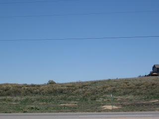
This picture, looking to the west of Highway 85 (Santa Fe), shows terraces of the South Platte.
This is a picture of Broadway alluvium on the road to Louviers. We are getting closer to East Plum Creek.


This alluvium here is the Louviers alluvium, and comes from weathered Pikes Peak Granite.
*************************************
Directions (from Library):
Continue on 14th Avenue east.
5.2 left on Lincoln
5.3 left on Colfax
6.1 left on Kalamath: Post-Piney Creek Alluvium
Continue south on Kalamath.
7.7 2nd and Kalamath. Mammoth tooth found underneath.
Continue on Kalamath. Kalamath becomes Santa Fe (Highway 85)
12.8 South Platte on right. Continue on Santa Fe.
20.9 Sand dunes and shrubs on left.
21.2 Terraces of the South Platte on left.
25.7 turn right to Louviers
26.9 Broadway Alluvium on right. Follow road across bridge and into Louviers. Stay on road to the left out of town. Road goes to left again back towards creek.
28.4 Louviers alluvium. U-turn. Go back to Highway 85
30.3 turn left on Highway 85.


No comments:
Post a Comment